OVERVIEW
| Commodity: | Gold and Silver |
| Deposit Type: | Low Sulphidation Epithermal Au-Ag Rhyolite Flow Dome Complex |
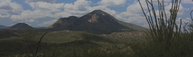
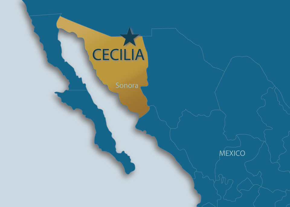
| Location: | Sonora, Mexico – 40 km SW of Agua Prieta |
| Size: | 7,739.4 has |
| Status: | Available |
| Highlights | 133.7 g/t Au and 335 g/t Ag top rock chip and grab samples |
The Cecilia Project is a district scale gold and silver low sulfidation epithermal system centered on multiple mineralized rhyolitic flow-dome complexes. Mineralization is related to structures of N30W and N70E with high grades assayed at the intersection of these structures. One of the workings at the Cerro Magallanes dome returned high grades up to 133.7 g/t Au and 335 g/t Ag. In addition to the rhyolite domes the underlying sedimentary Cabullona group and Paleozoic limestone provide an environment for replacement style mineralization at depth. Riverside’s current analogues for Cecelia are Endeavor Silver’s Pitarrilla deposit and Fresnillo’s San Julian deposit, which contain 526 million oz Ag (Measured + Indicated 1) and over 230 million oz Ag respectively.
The Cecilia Project is located 40 km southwest of the Mexico-U.S.A. border town of Agua Prieta in Sonora, Mexico. The project is directly accessible by well-maintained dirt road from highway 17.
The Cecelia Project is currently under Option to Fortuna Silver Inc of Vancouver. The terms of the agreement are:
First Option: 5 years to earn 51% by spending US$3.75M in work and paying US$150,000 in cash payments to Riverside with required work of at least $500,000 in the first year for the Option and Riverside has the drill permits in hand. Fortuna has paid Riverside the initial $25,000 on signing and pays $25,000 more on filing the agreement in Mexico. Then pays Riverside $25,000 each year plus Riverside acts as operator for the program with a 10% management fee on top of the work spending commitments each year.
Second Option: Upon completion of First Option, Fortuna may elect to progress with a second option to earn to 80% by spending an additional $2.25M in work over 3 additional years.
Third Option: After completing Second Option, Fortuna may elect within 120 days to pay Riverside $5M cash and grant Riverside a 2% NSR where 1% NSR may be purchased before commercial production for $3M thereby Fortuna earning 100% interest in the project.
1 https://edrsilver.com/news-media/news/endeavour-silver-announces-initial-mineral-resourc-4862/
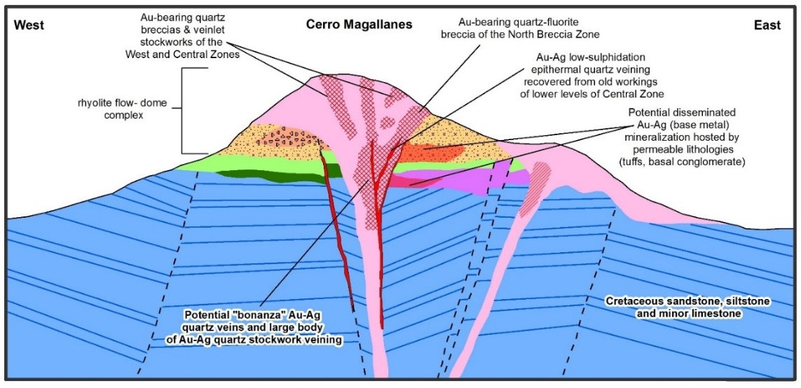
Figure 1: Interpretative cross-section of Cerro Magallanes rhyolitic dome
Project History
As many as 30 abandoned exploration adits, small underground galleries and surface prospect pits are distributed over the upper slopes of Cerro Magallanes, which are believed to date back to the early decades of the 20th Century.
In the early 1980s the Consejo de Recursos Minerales (CRM) initiated a project at Cerro Magallanes over a 3-year period and carried out a comprehensive exploration program, including:
- 896 km2 of regional mapping
- 635 surface rock chip samples
- 14.3-line kilometres of induced polarization
- 1,412 m of underground mapping
- 4 diamond drill holes totalling 732.3 m
In April of 1994, Cambior Exploracíon entered into an option-to-purchase agreement with the Mines General Directorate (DGM) for the project. Cambior terminated the contract at the end of the first 18-month term, their work is summarized below:
- 9 km2 1:2,500 orthophoto and topo map with 5 m contours
- 6 km2 of geological mapping at 1:2,500
- 12.85 line-kilometres of induced polarization, ground magnetic survey over 2.8 km x 2.4 km
- 666 surface rock chip samples
- 1,200 m of underground mapping, 388 underground rock chip samples
- drilling of 19 diamond drill holes totaling 3,817.6 m
Minerales El Prado S.A. de C.V., the Mexican subsidiary of Chesapeake Gold Corp., was the next company to acquire the project. El Prado conducted rock sampling programs between 2004 and 2009 and collected a total of 738 surface rock chip samples. From 2009 until 2013 essentially no work was done.
In February of 2013, Precipitate Gold Corp. entered into an option agreement with Gunpoint Exploration Ltd., who then controlled the La Cecilia project. Precipitate Gold, collected 43 surface rock chip samples and resampled and analyzed 35 samples from 2 drill holes.
In 2017, Riverside Resources undertook rock-chip sampling to confirm the existence of the more intensely mineralized gold occurrences found on the Cerro Magallanes flow dome. Riverside confirmed work done by previous explorers, leading to additional mapping and a large soil grid completed in 2018, totaling over 1,300 samples.
Through this work Riverside Resources successfully discovered new mineralized areas targets including the: Cerro Magallanes, La Mesa, Casa de Piedra, Medias Rojas, Cruz I and II and Magallanecito another dome complex.
Recent addition of 1,801 ha to the Cecilia Project land package has expanded work possibilities and discovery of new targets to the east.
Highlighted Exploration Results
Riverside completed a 1st phase exploration program at the North Breccia and Central Zones in 2017 collecting 91 rock chip and grab samples. Thirty-three (33) of the 91 samples yielded gold assays greater than 0.5 g/t gold (Au) with five samples assaying greater than 3 g/t Au.
The three-best sampled assays were (see press release dated June 6, 2017):
- 133.7 g/t Au with 288 g/t silver (Ag)
- 58 g/t Au with 207 g/t Ag
- 8.42 g/t Au with 87.8 g/t Ag
Nineteen (19) of the 91 samples have silver contents greater than 100 g/t Ag, six of these samples yielding assays that were greater than 200 g/t Ag and the maximum silver assay was 310 g/t Ag.
In September of 2018, Riverside completed a regional soil sampling program. The soil survey covered approximately 30% of the 50 km2 Cecilia 1 concession (see Figure 2 below and press release dated March 5, 2018), and has expanded the targeting around the known central Cerro Magallanes area of the Cecilia Project. The Company continues to advance and refine the known central targets and is also placing equal priority on new property-wide target generation.
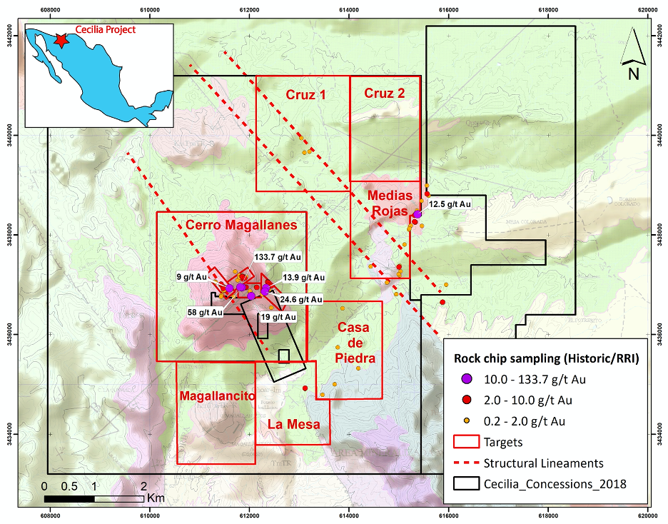 Figure 2: Zoning Map of the Cecilia Project Showing a Range of Targets
In October 2018, Riverside reported on rock chip channel samples from the Cerro Magallanes area continuing to expand exploration to different regional areas at the Project (see press release dated October 2, 2018). Riverside’s rock sampling results from the main central rhyolitic dome complex verifies and expands upon historical sampling for gold within breccias and veins on Cerro Magallanes. Dome margins also show positive potential for near surface gold targets. This channel sampling program included 305 samples returning assays ranging from <0.05 to 19.0 g/t Au. Sampling shows consistent gold from the top of Cerro Magallanes (2200m) at the San Jose Target downslope to the northeast to the Agua Prieta-North Breccia Target and through to the Central and East Target (1760m) areas.
Results across the Cecilia 1 concession shows significant upside, with high-grade samples at Medias Rojas up to 12.5 g/t and a 2-m channel sample assaying 2.3 g/t at La Mesa Target. Similar to Cerro Magallanes, mineralization follows primary northeast and northwest trending structural lineaments for which the intersection serves as an excellent migration path for gold-bearing fluids.
Geology and Mineralization:
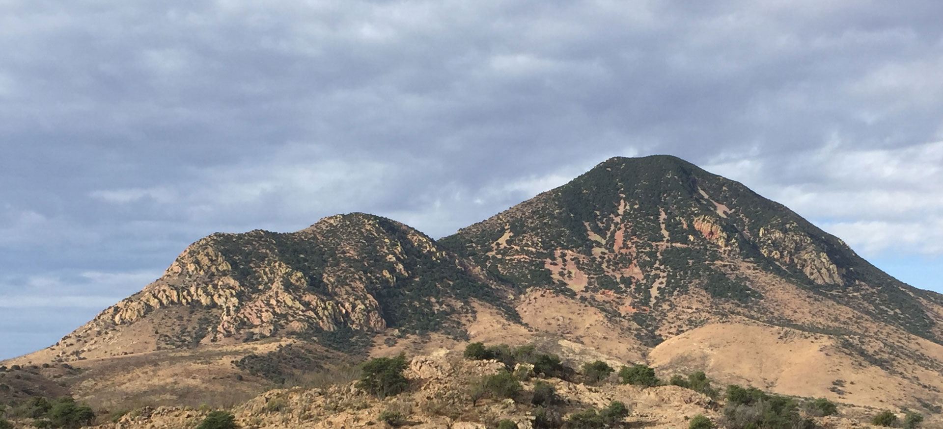
The Cecilia project is centered on a large middle Tertiary age (Oligocene) rhyolite flow-dome complex that forms the prominent topographic feature of Cerro Magallanes. The dome complex intrudes and unconformably overlies a sequence of marine clastic sedimentary rocks consisting of interbedded siltstone, fine-grained sandstone and thin layers of intraformational, immature pebble conglomerate (middle Cretaceous Cabullona Group), providing a perfect setting for replacement style mineralization at depth. This sedimentary sequence also extends over the Cecilia 1 and 2 concessions, in contact with Paleozoic limestone and Precambrian granite uplifted through horst and graben formation.
Gold mineralization is concentrated along NW and NE regional structural lineaments. Riverside Resources identified four targets on the Cerro Magallanes dome and six others outside of the dome. All of them show extensive alteration and sub-continuous high grades. Surface geochemistry indicates that that the areas sampled are above the boiling zone suggesting gold bearing mineralization could be intersected at shallow depth at these targets.
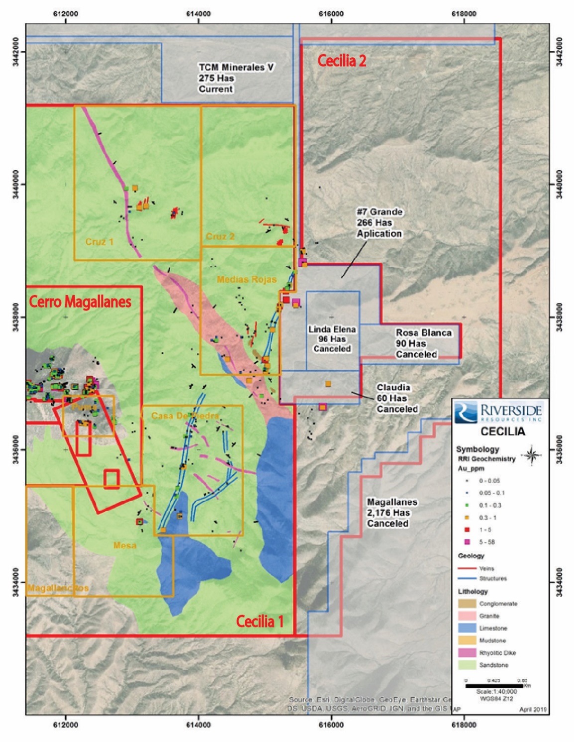 Figure 3: Geological map of Cecilia 1 and Cerro Magallanes
Cerro Magallanes Targets:
Cerro Magallanes Dome encompasses four sub-targets: San Jose, North Breccia, Central Target and East Target (Figure 4). Riverside’s extensive work program since 2017 have shown a vertical variation with significant concentration of Ag at the base of the dome along the eastern slope to gold-only enriched at the top of Cerro Magallanes. Three specific elevation: 1,700 m, 1,900 m and 2,100 m comprise most of the high-grade, which suggest multiple mineralizing events within specific structural settings, along dome margin and stratigraphy. This style of mineralization is very similar to the Pitarilla mine in Durango, where large volumes of mineralized rock can be found in addition to high-grade structural bounding margins. This hypothetic target at Cerro Magallanes would be at 300 to 500 meters depth from the top of the dome, evident by the presence the Cabullona sediments outcropping at 1,650 m elevation on the eastern slope.
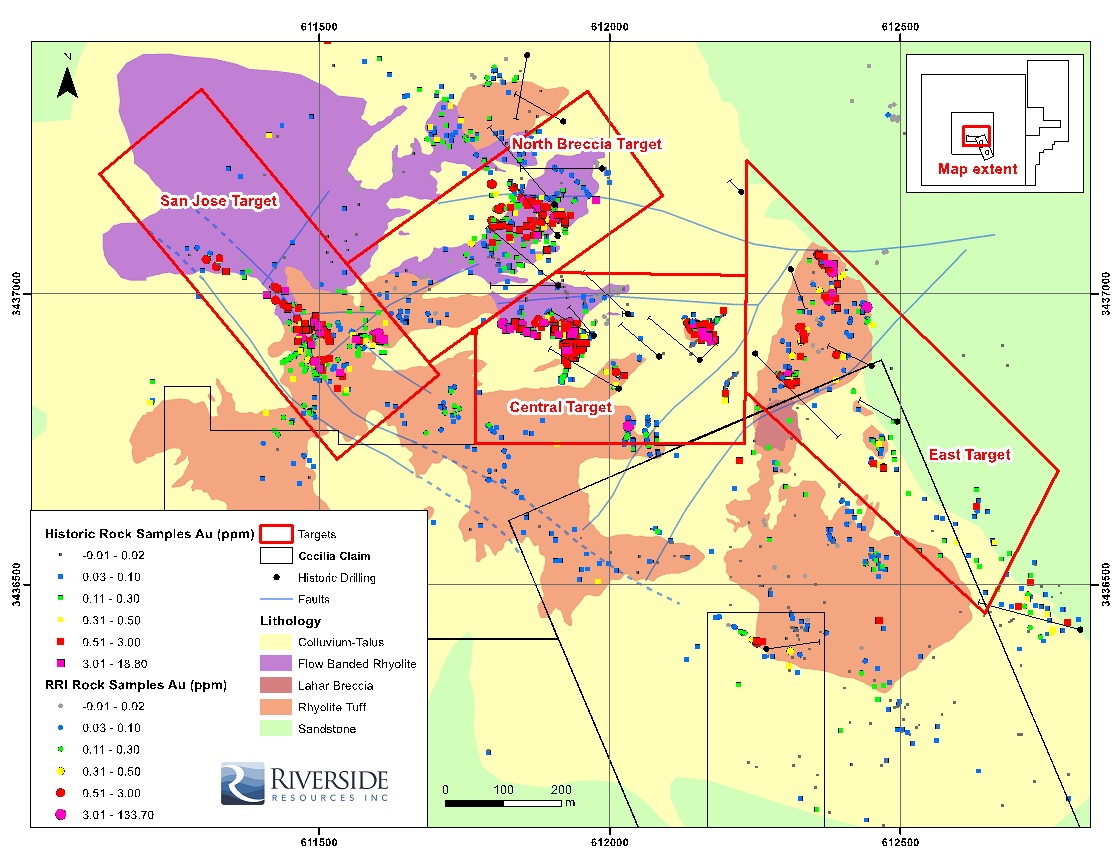 Figure 4: Geological map of Cerro Magallanes with historical and Riverside’s rock sampling
- The San Jose target is located at the top of the dome along the primary structural zone bisecting the peak of Cerro Magallanes. There are over half a dozen of old workings here, some of them accessing multiple parallel fault zones carrying gold mineralization of 47 m @ 1.12 g/t Au, 8 m @ 0.91 g/t Au (Cambior, 1995). At surface, Riverside’s assays returned 3.0 and 7.9 g/t Au for a 1.5 m long channel and up to 9 g/t Au rock chip sample. These veins show classic epithermal multigenerational opening and filling textures typical of feeder zones like those at the San Julian Mine in Chihuahua also of the same mid-Tertiary age.
- North Breccia target has an outline of 250 m by 100 m and is marked by multiple zones of hydrothermal brecciation in porphyritic, flow banded and flow breccia rhyolitic rocks with strong hematite-stained silica alteration. Locally, crystallization of quartz and fluorite in open-space as well as veinlets is visible, however the area shows primarily extensive fractures along NW-SE trend with strong hematite and clay-rich gouge material. Since 2017, Riverside Resources collected over 75 rock-chip samples in this area. Twenty-six of these samples returned gold assays ranging from 0.41 to 7.46 g/t Au. CRM and Cambior both drill-tested this area and intersected a 30 m interval of 1.41 g/t starting 4.0 meters downhole (138-95-08). The same portion of mineralization was intersected in hole 139-95-19 and produced an 8-m-long interval that averaged 0.65 g/t Au.
- Central target is located along the same northwestern trend as the North Breccia and returned one sample of 133 g/t Au and 335 g/t Ag in mine dump. There are numerous small underground workings reportedly dating back to the 1940s that extend as a linear feature from the peak of Cerro Magallanes down the slope (Figure 5). Riverside Resources collected 30 samples across the target, which returned between 0.5 and 133.7 g/t Au with values worth noting such as 58 g/t Au and 19 g/t Au with reported respective silver values of 288 g/t Ag and 335 g/t Ag.1 The Central target was tested by 5 drill holes in 1995. Hole 139-95-17 intersected 42.0 m averaging 0.49 g/t Au with a maximum assay of 3.26 g/t Au. Hole 138-95-9 & -10 intersected 36 m at 0.2 g/t Au and 60 m at 0.2 g/t gold.
1 See press release dated June 6, 2017
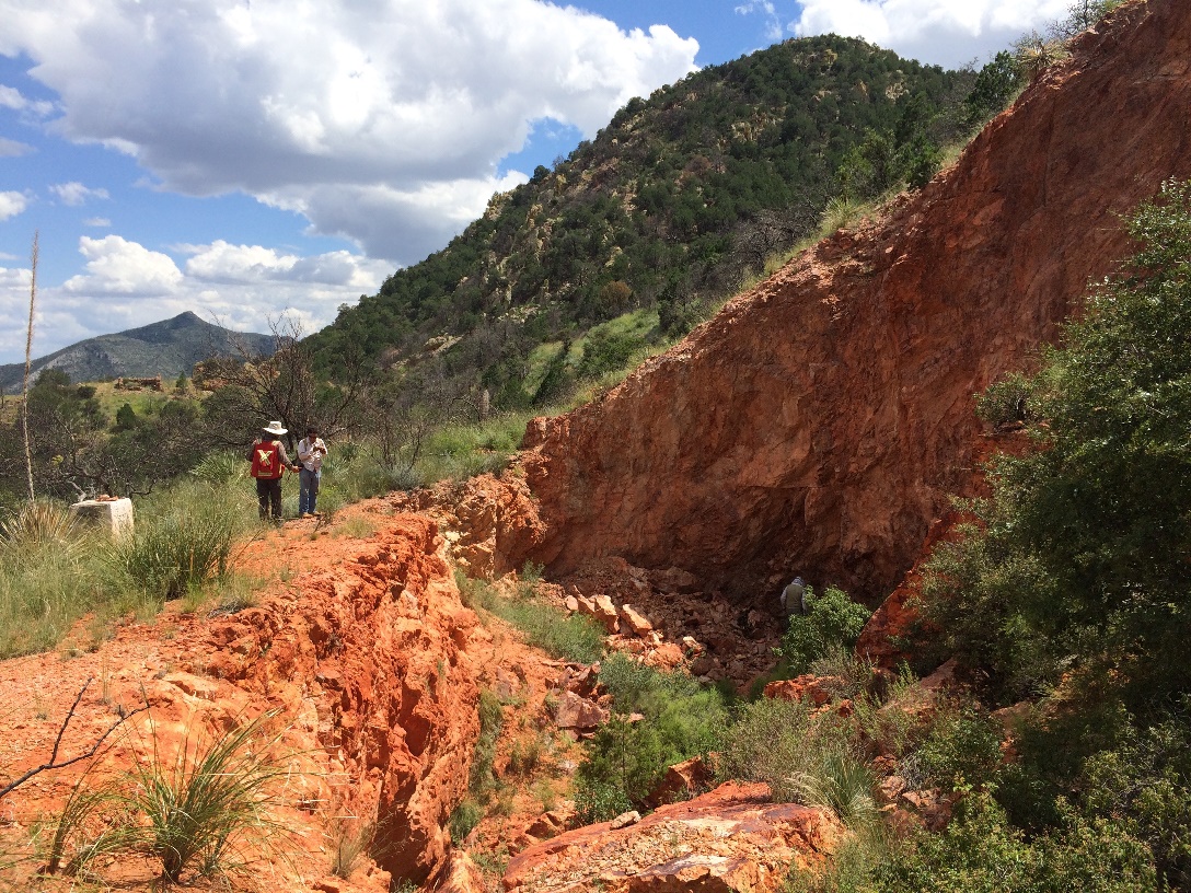 Figure 5: Collapsed underground workings of Obra 14 at Central target. View to E-SE.
Cecilia 1 Concession Targets
Cecilia 1 concession encompasses a wide range of rocks from Precambrian granite, to Paleozoic limestone and Cretaceous Cabullona sedimentary group. This succession was strongly affected by major NE and NW structural corridors that created a horst and graben terrain and northwest trending rhyolitic dikes. The six targets, Casa de Piedra, La Mesa, Medias Rojas, Cruz 1, Cruz 2 and Magallanecito are located along these NE and NW regional structures. Soil sampling geochemistry suggests near-boiling zone geochemistry with targets anomalous in gold exceeding 1 g/t (Precipitate Minerals, 2016, unpublished).
- Casa de Piedra and La Mesa target both show the same style of mineralization primarily along NE trending faults extending for at least 2 km across the project area. Alteration and veining are visible within the Cabullona group rocks and increases in the limestone unit noted as jasperoid along structures and near rhyolitic dikes (see Figure 6 below). Some of the best results are located at La Mesa target are: 2.81 g/t Au along a 2 m channel sample; and 0.907 g/t Au and 0.497 g/t Au at Casa de Piedra1. This area is believed to host a deeper target closer to the boundary of limestone and the quartzite.
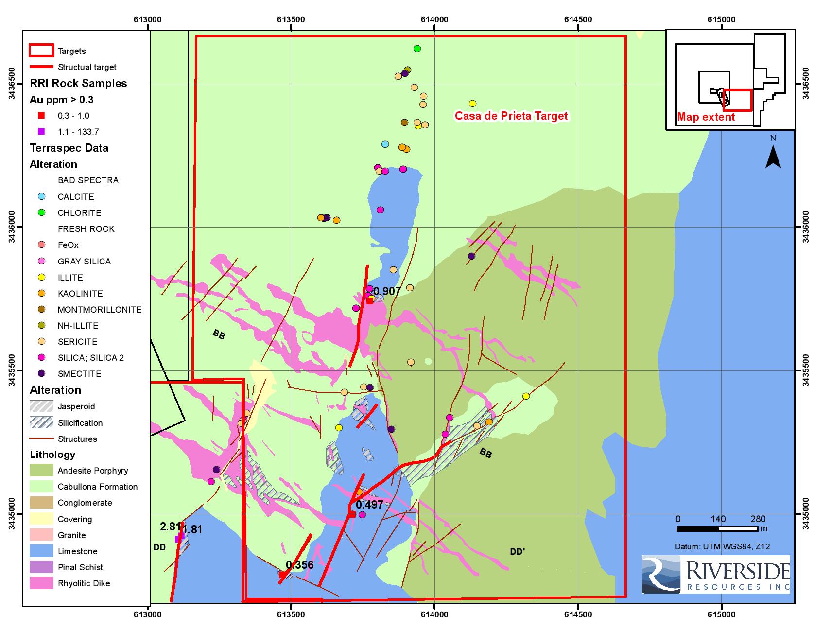
Figure 6: Casa de Piedra geological map showing Riverside’s Terraspec analysis, rock samples and structural targets
- Medias Rojas is located along a NE trending structural corridor along which a more or less continuous vein/breccia/stockwork zone can be traced for at least 250 m. The corridor is about 20 m wide and comprises 3 to 5 parallel quartz veins with hematization of rare pyrite, sphalerite and galena. Riverside’s best samples returned 12.5 g/t Au in sandstone and 8.5 g/t Au in rhyolitic dike material. Nineteen of the rock chip samples returned over 0.3 g/t Au. The extent of the mineralization along strike has not been established, but recent work suggests that the vein system extends to the northwest onto the Cecilia 2 concession.
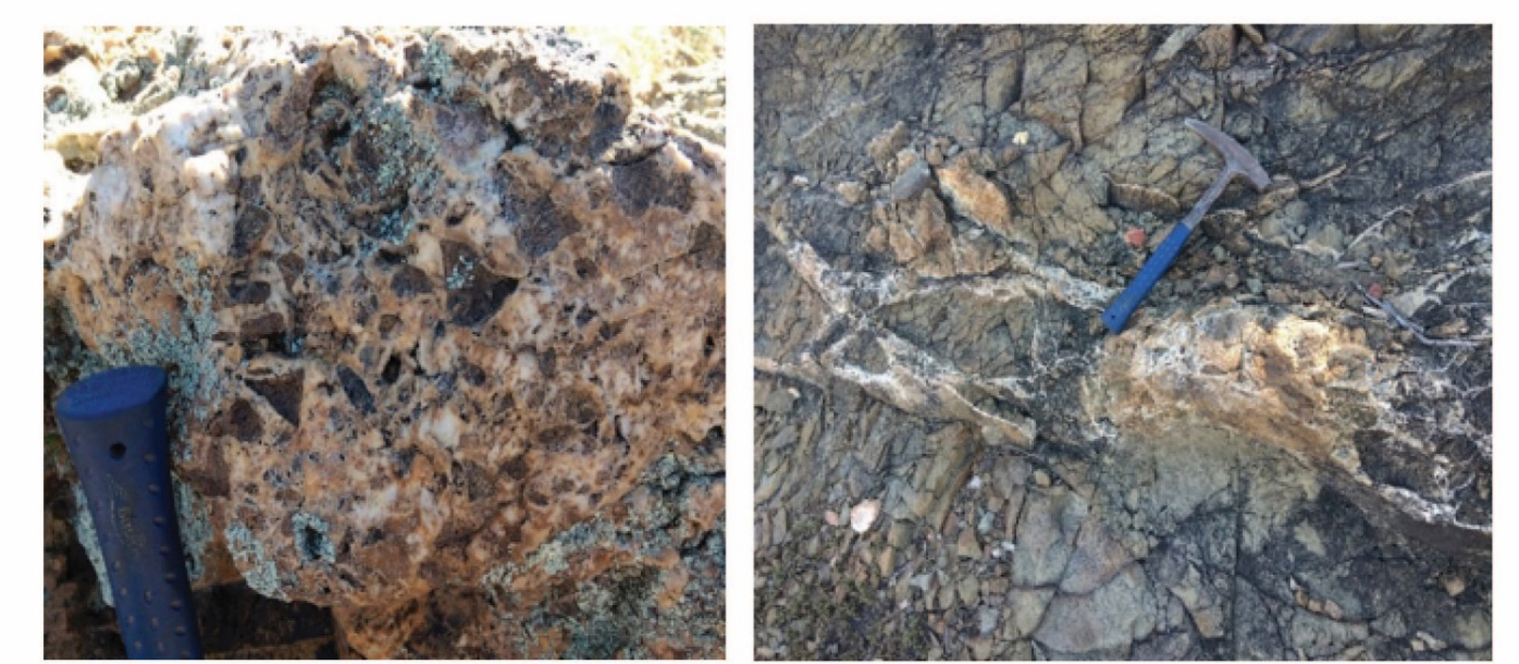 Examples of breccia and veining within the Medias Rojas structural corridor.
- Cruz I and II are located to the north of the Cecilia 1 concession along and near a major northwest trending corridor that extends for at least 4 km. Geochemistry from soil sampling shows anomalous Te, Au, Pb, Zn and Cu, suggesting that Cruz I and II could be located within the base-metal horizon of an epithermal system. In the field, mineralization is associated with veins and stockwork and alteration zones up to 100 m wide with pervasive, widespread sericitic and silica alteration; sulphides are rare but noted in this area. At Cruz I, ten samples were collected with four samples returning 0.1 to 0.5 g/t Au 1.
- Magallanecito is an additional rhyolitic dome similar to Cerro Magallanes. Results from sampling highlights a high correlation between gold and silver making this target a priority for additional groundwork.
Phase 1 Sampling Program:
The ongoing Phase 1 exploration program through November 2020 under the Carlyle-option has delivered additional data, which includes:
- First results from the initial batch of 21 rock channel samples collected from Cerro Magallanes that returned: 43.2 g/t Au, 5.6 g/t Au and 2.5 g/t Au (see Table 1 below);
- Channel sampling results collected at San Jose Target yielding 48.3 g/t Au over 0.75 m (see Table 2 below);
- Results from soil sampling at the Casa de Piedra target within the sedimentary Cabullona group;
- Results from Aster processing highlighting altered corridors across the district scale property;
- Topographic DEM produced from drone survey
Table 1: Top Four (4) of 21 Gold Assay Results from Current Channel Sampling Program with Carlyle
| Sample # | Au (ppm) | Target |
| RRI-6038 | 43.2 | San Jose |
| RRI-6034 | 5.6 | San Jose |
| RRI-6046 | 2.5 | North Breccia |
| RRI-6047 | 1.08 | North Breccia |
Exploration at Cerro Magallanes Target:
Phase 1 exploration has defined and confirmed extensive high-grade mineralization on surface at the San Jose and North Breccia targets as highlighted in Figure 7 below. The latest sampling returned 43.2 g/t Au and 5.6 g/t Au from part of a more extensive structural corridor for which historical work has defined over 300 m in strike length and 20 m in width. Sampling in 2017 by Riverside from a mine dump area returned samples of 133.7 g/t Au and 58 g/t Au. Current interpretation suggests a potential intersection at depth of the San Jose and North Breccia structures identifying possible bonanza style mineralization.
Table 2: Sample results from the November 10th channel sample batch at San Jose target
| Sample # | Au (ppm) | Target | Channel Thickness | Rock Type |
| RRI-32975 | 48.3 | San Jose | 0.75-m channel | Underground silicified fluidal rhyolite |
| RRI-32997 | 0.86 | San Jose | 1.70-m channel | Silicified breccia |
| RRI-32976 | 0.78 | San Jose | 0.85-m channel | Underground silicified breccia |
| RRI-32978 | 0.66 | San Jose | 1.60-m channel | Silicified breccia |
| RRI-32974 | 0.66 | San Jose | 0.80-m channel | Underground silicified breccia |
| RRI-32998 | 0.56 | San Jose | 1.25-m channel | Silicified fluidal rhyolite |
Channel samples yielding up to 48.3 g/t Au over 0.75 m at the San Jose Target (see Table 1 above). The 36-sample batch with over 43% of the gold assays higher than 0.2 g/t Au. All samples were collected using a hand saw to ensure continuity and thickness of reported grade-intervals. This latest batch of samples is from brecciated and silicified rhyolite from underground workings as well as at surface, which collectively form part of the La Cueva structural corridor parallel to the main San Jose fault.
By incorporating surface data and geophysics survey (Magnetic and Induce Polarization), Riverside’s geologists were able to provide a better understanding of the structure for targeting of the mineralization. Hosts and feeder zones of the mineralization throughout the rhyolitic dome is controlled by both northwest and northeast structural corridors. Mapping and sampling have delineated a 600-m long high-grade zone open along trend, called the Agua Prieta structural zone (see Figure 1B below). The trend is notable by its reddish-oxide stained rocks outcropping prominently along the eastern slope of the dome. Intersections between feeders and dome margins, as indicated by the magnetic survey correlate with the Central and North Breccia targets.
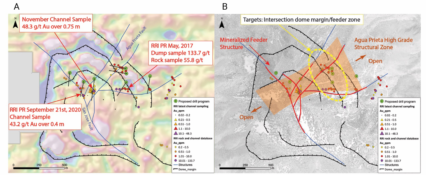
Figure 7: Maps of the Cerro Magallanes dome including interpretation of the dome margin and simplified structures. Proposed drill holes are subject to adjustments. Figure 1A - 1DV magnetic survey results with the drill plan and Riverside’s rock and channel sampling; Figure 1B - Target interpretation and mineralized feeder system.
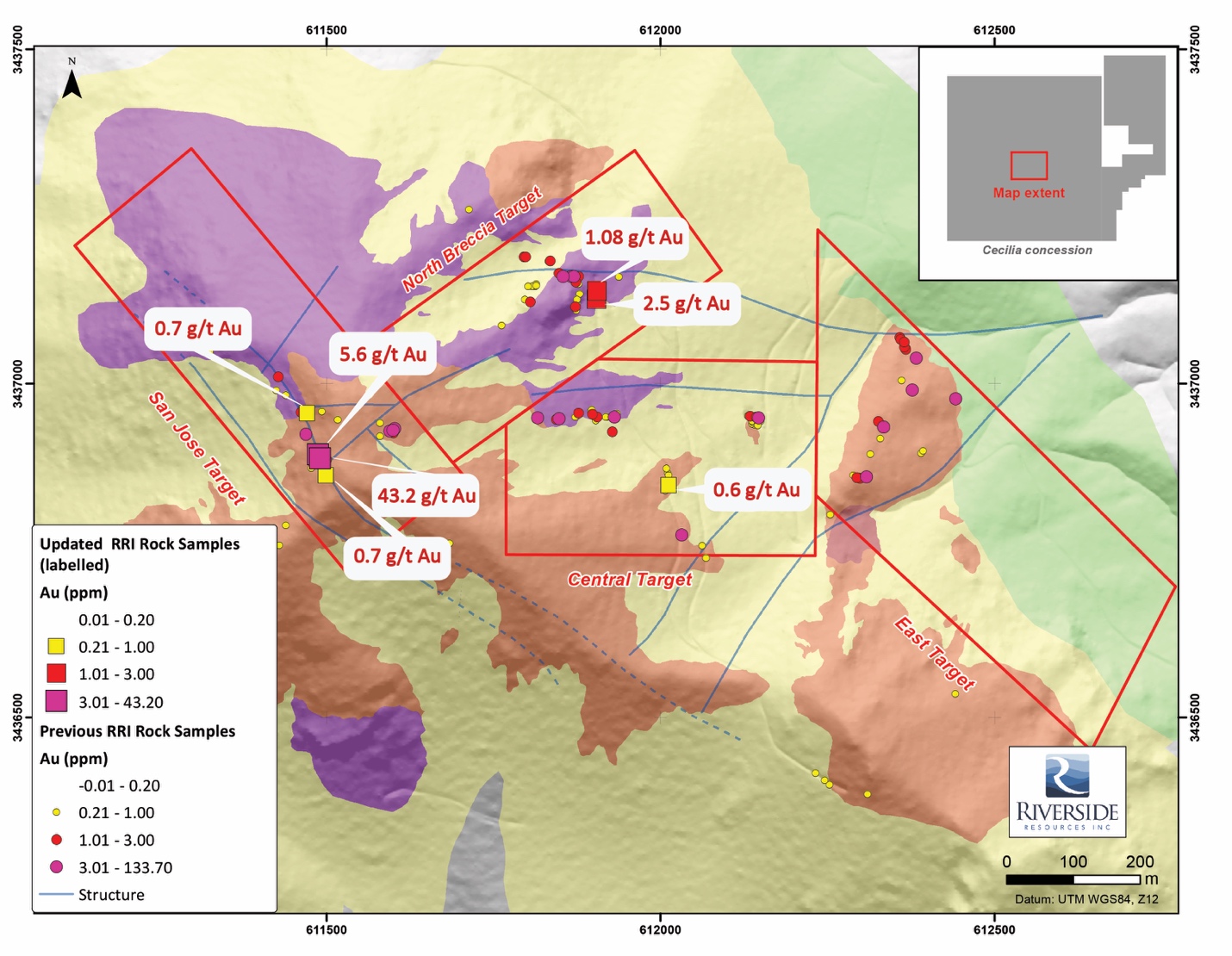
Figure 8: Simplified Geological Map Including Recent RRI Channel Sampling
Mineralization at the San Jose target consists of grey quartz, opalescent silica, fluorite and silicification within structural breccia and upper dome shears. The primary structure is oriented northwest along which conjugated structures form sets of northeast and easterly oriented faults. It is interpreted that the primary fluid path for mineralizing fluids follows a northwestern lineament, which allows ore shoot deposition of gold and silver mineralization at fault intersections as well as along dome margins.
The North Breccia, Central and East targets are associated with increases in precious and base metals, showing boiling textures and dissolution of clasts. These indicators make us believe that historical drill holes and recent surface work could define a shallow horizon (upper levels) within an epithermal system.
Exploration at district scale:
New data from soil sampling and Aster processing show a corridor of alteration following northwest and northeastern oriented structures as shown in the figure below. In addition, widespread gold-bearing quartz veins with gold values up to 12.5 g/t Au confirm the presence of fluid migration throughout the property and especially along northeastern structures. The divergence in orientation of the northwestern Cerro Magallanes primary fluid migration path and the northeastern trend outside of the dome could be explained by difference in rheology for which the rhyolite dikes act as an aquiclude in the sedimentary units. This interpretation has helped guide target definition (see Figure 9 below).
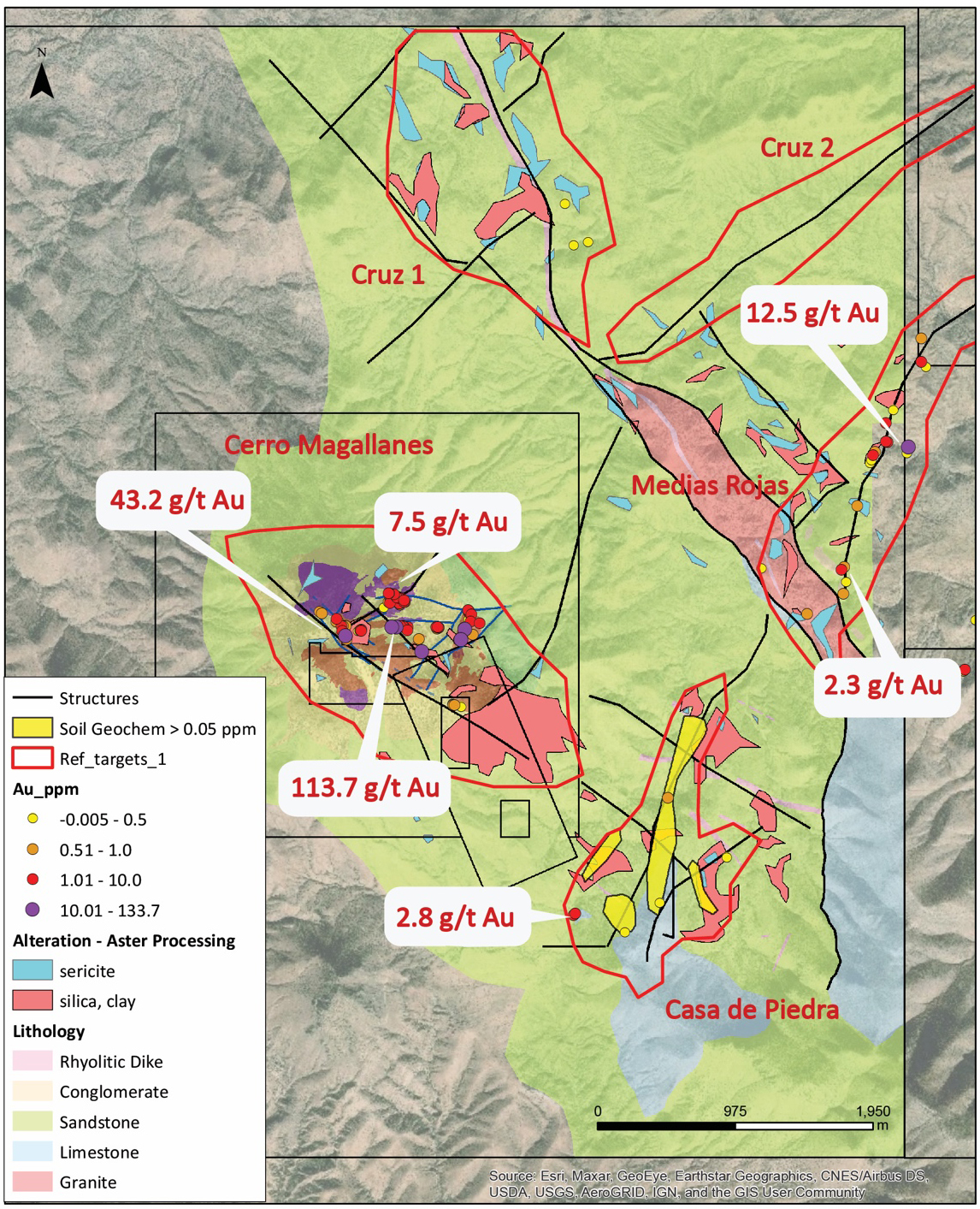
Figure 9: District Scale Targeting Refined Using Aster Processing, Soil Sampling and Historical Rock Sampling
2021 Drill Program
In Spring 2021 Riverside and partner, Carlyle Commodities Corp. completed the Phase I Drill campaign. The program consisted of a total of seven (7) drill holes.
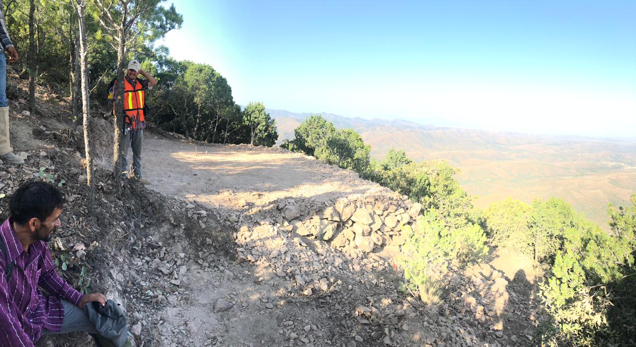
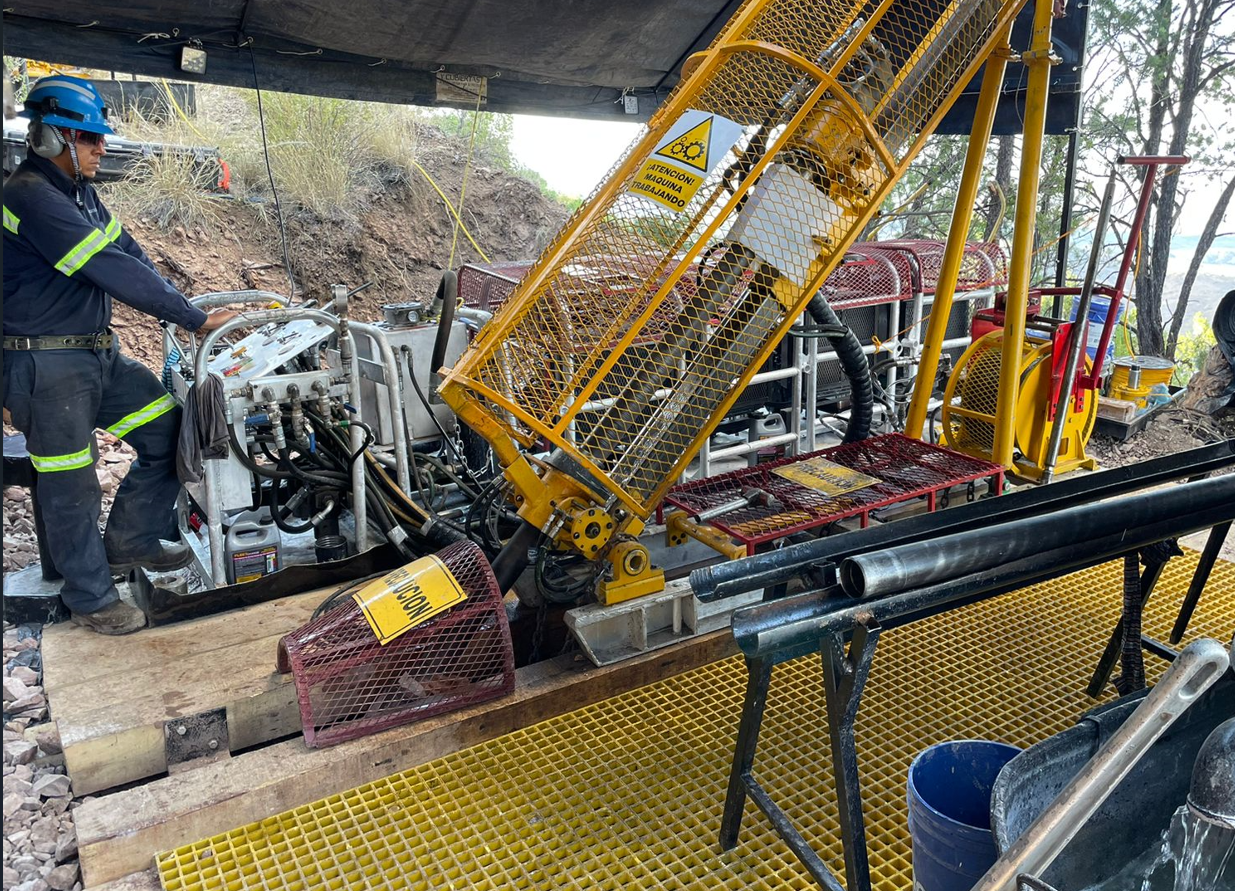
Image: Progressing towards drilling. Drill pad preparation at the Cecilia Project
North Breccia Target
Anomalous gold mineralization was intersected in all seven drill holes, with the best intercepts being 24.2 m of 1.51 g/t Au starting from only 2.30 m downhole at the North Breccia Target (CED21-005) and in hole CED21-006 from 106.7 to 110 which retuned 3.7 g/t over a true width of 3.3 m. A further 8.9 m of 0.64 g/t Au intercept was cut near end-of-hole starting from 40.35 m. Assays remain pending for another slightly deeper drill-hole at the North Breccia Target (See 3D Figure below). This first phase drill campaign included mostly shallow drill-holes, which successfully demonstrate a well-developed hydrothermal system near surface, with significant room to extend mineralization both laterally and to greater depths with subsequent drilling.
Table 1: First assays received from the North Breccia drilling, including two intercepts. Summary of additional results are listed further below in table 2.
| Hole_ID | From (m) | To (m) | Interval (m) | Grade (g/t Au) |
| CED21-005 | 2.3 | 26.5 | 24.2 | 1.51 |
| CED21-005 | 40.35 | 49.25 | 8.9 | 0.64 |
| including | 43.95 | 47.25 | 3.3 | 1.32 |
| CED21-006 | 106.7 | 110 | 3.3 (True width) | 3.7 |
| including | 106.7 | 108 | 1.3 (True width) | 8.82 |
Notes: Cut-off grade used for calculating intervals is 0.2 g/t Au. All reported intercepts are downhole lengths (estimate true width will be determine with the hole CED21-006, for which logging indicate a zone of interest of about 4 meters.
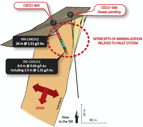
Figure: 3D section of the drilling at North Breccia target from Riverside and Carlyle exploration program. Hole 005 has intersected the fault system and shows extent of mineralization with relation to the fault system. Mineralization corresponds to a combination of breccia, fault and strong silicification.
The first drill program from Riverside and Carlyle was focused on targeting the hydrothermal system identified at two principal elevations: 2,200 m and 1,900 m, respectively corresponding to the San Jose Target and the North Breccia Target. By doing so, Riverside’s team was able to test the continuity of the mineralized structures at shallow depth.
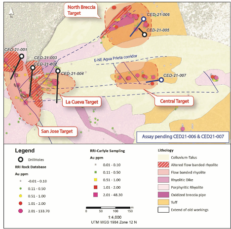
Figure: Simplified map of the Cerro Magallanes eastern slope with the first phase drill program
The San Jose Target
A total of 3 holes were drilled into the San Jose Target (CED21-001, 002, 003) and 1 hole (CED21-004) to test the La Cueva Target identified as the northeastern structural junction with the east-west Agua Prieta structural corridor including the North Breccia Target and the Central Target as shown in Figure 2.
The San Jose Target was originally identified from a historical working that included extensive tunnels up to 80 m deep and stopes, for which the extent is not known. Previous sampling taken from the stope wall during 2020, returned high grades up to 48 g/t Au in a sawcut channel sample over 0.75 m. Results from drilling show a wide interval of lower grade enveloping high-grade pods at shallow depths. The drilling at San Jose finds extensive and intensive silicification which appears to be the upper zones of low sulfidation epithermal fluids which could be the upper distal outflows from potentially gold rich veins below. This type of alteration is found in other epithermal centers in Sonora, Mexico and the results so far are favorable for this target.
Drill core shows the mineralized zone identified in the drill holes is primarily concentrated within fault zones and is associated with moderate to intense silicification. The fault system extends to depth and so far, appears to become a lot wider which is also reflected in the grade thicknesses. The San Jose target was never drilled prior to this program. Drilling so far suggests the structures are widening at depth and warrant additional drilling.
| Hole_ID | From (m) | To (m) | Interval (m) | Grade (g/t Au) |
| CED21-001 | 19.5 | 21 | 1.5 | 0.21 |
| CED21-001 | 38.15 | 39 | 1.3 | 0.69 |
| CED21-002 | 31.15 | 32.2 | 1.05 | 0.49 |
| CED21-002 | 91.25 | 97.2 | 5.95 | 0.2 |
| CED21-003 | 42.85 | 45.95 | 3.1 | 0.52 |
| CED21-003 | 50.1 | 54.5 | 4.4 | 0.23 |
| including | 54 | 54.5 | 0.5 | 0.91 |
| CED21-003 | 89.55 | 99 | 9.45 | 0.23 |
| CED21-003 | 114.15 | 116.3 | 2.15 | 0.26 |
| CED21-003 | 118.75 | 120.75 | 2 | 0.39 |
| CED21-003 | 122 | 123 | 1 | 0.55 |
| CED21-003 | 154 | 157.45 | 3.45 | 0.35 |
| CED21-004 | 11.4 | 15.7 | 4.3 | 0.29 |
| CED21-004 | 45.45 | 51.7 | 6.1 | 0.43 |
| including | 47.4 | 48.35 | 0.95 | 1.09 |
| CED21-004 | 82.2 | 85.2 | 3 | 0.87 |
| CED21-004 | 116.2 | 117.05 | 0.85 | 1.08 |
| CED21-005 | 2.3 | 26.5 | 24.2 | 1.51 |
| CED21-005 | 40.35 | 49.25 | 8.9 | 0.64 |
| including | 43.95 | 47.25 | 3.3 | 1.32 |
| CED21-006 | 34.5 | 40.15 | 5.65 | 0.39 |
| including | 34.5 | 36.5 | 2 | 0.78 |
| CED21-006 | 47.5 | 49 | 1.5 | 0.6 |
| CED21-006 | 70.2 | 70.7 | 0.5 | 0.2 |
| CED21-006 | 106.7 | 110 | 3.3 (True width) | 3.7 |
| including | 106.7 | 108 | 1.3 (True width) | 8.82 |
| CED21-007 | 35.35 | 37.65 | 2.3 | 0.19 |
| CED21-007 | 45.75 | 48.9 | 3.15 | 0.31 |
| CED21-007 | 60.75 | 63.8 | 3.05 (True width) | 0.67 |
| including | 62.3 | 63.8 | 1.5 (True width) | 1.18 |
2024 Drill Program
Riverside completed a five-hole, 2,250-meter drilling program designed to test Magallanes main area, plus the East Target and then 2 new target areas. Drilling hydrothermal alteration, gold quartz veins and expanded the depth and scale of the Cecilia different targets. The gold mineralization in each target area has now shown to have depth extending from the surface gold sampling that has been developed by the work of Riverside. The results appear similar and consistent with low-sulfidation epithermal systems, similar to those seen at the Mercedes Mine (Sonora, Mexico) and the Oatman Gold District (Arizona, USA). The 2024 drill holes stepped out across the district, expanding mineralization at Cerro Magallanes, the Mesa Ranch area, and the South Mesa Fault Zone. Based on the success of this program, follow-up geophysical surveys and additional exploration are planned for 2025 to further refine targets and advance exploration at Cecilia.
Highlights from the 2024 Drill Program
San Jose Vein System (North Breccia Target)
Two holes were drilled potentially extending the San Jose structure, building on previous results. Drilling confirmed the continuity of this extensive vein system to depths of 500 - 800 meters. Hole CED24-010 returned an intercept of 3.41 g/t Au over 4 meters, starting at 76 meters depth, with a secondary intercept of 0.39 g/t Au over 5.25 meters at 319 meters. These results demonstrate vertical continuity over 500 meters from surface and highlight the potential for deeper gold-bearing structures.
East Target
A single hole was drilled perpendicular to previous drilling to better define the structural dip of the system. The hole intersected six gold-bearing intervals, including 0.38 g/t Au over 1.75 meters from 149.25 meters depth. Thick alteration zones observed in this hole confirm the presence of significant hydrothermal activity in the eastern Magallanes system, supporting further exploration.
Mesa Ranch Area (Mayra Vein)
The Mayra Vein was tested for the first time with drilling in 2024. Hole CED24-011 intercepted multiple vein zones, including 0.21 g/t Au over 2 meters from 281 meters depth. The mineralization aligns with surface-mapped veins extending over 700 meters along strike, suggesting further potential for epithermal gold mineralization.
South Mesa Fault Zone (Mesa South)
The final hole of the program targeted the 10 km-long South Mesa Fault, an important structural corridor. Hole CED24-012 intersected the fault at 110 meters depth, revealing a 5-meter-thick brecciated shear zone. Surface sampling along strike has returned gold values exceeding 2 g/t Au, supporting additional exploration in early 2025 to evaluate continuity and expand known mineralization.
Geology Map with Location of Drill Holes in Targets:
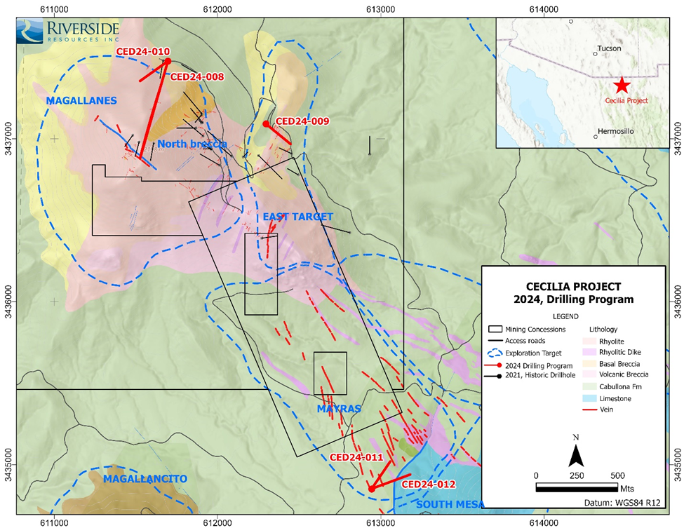
Figure 1- Geology map and location of the five 2024 drill holes shown in red. The straight and thin black lines near Magallanes are drill holes from previous campaigns. This new program stepped out to test the East Target (CED24-009) and the Mayras and South Mesa with single holes
The cross-section figure below highlights hole CED24-010 from the drill program, which demonstrates the intersections of multiple vein structures. These structures are now interpreted to potentially extend over 800 meters vertically, suggesting they could be part of a significant epithermal system.
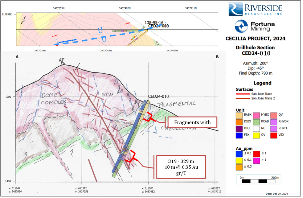
Figure 2- Cross section of the Magallanes Dome showing the volcanic units and structures
The Q4 2024 drill program successfully confirmed gold mineralization across multiple targets, extended known structures, and provided critical data for the next phase of exploration to continue.
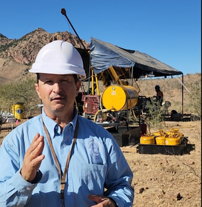
At drill site during program.
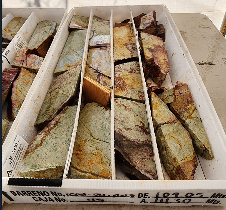
Core from hole 9 with veining, alteration, oxidation of the host rhyolite east side of Magallanes with gold values.
Drilling northern edge of Magallanes Hill, site hole 8 and 10 from same collar location.
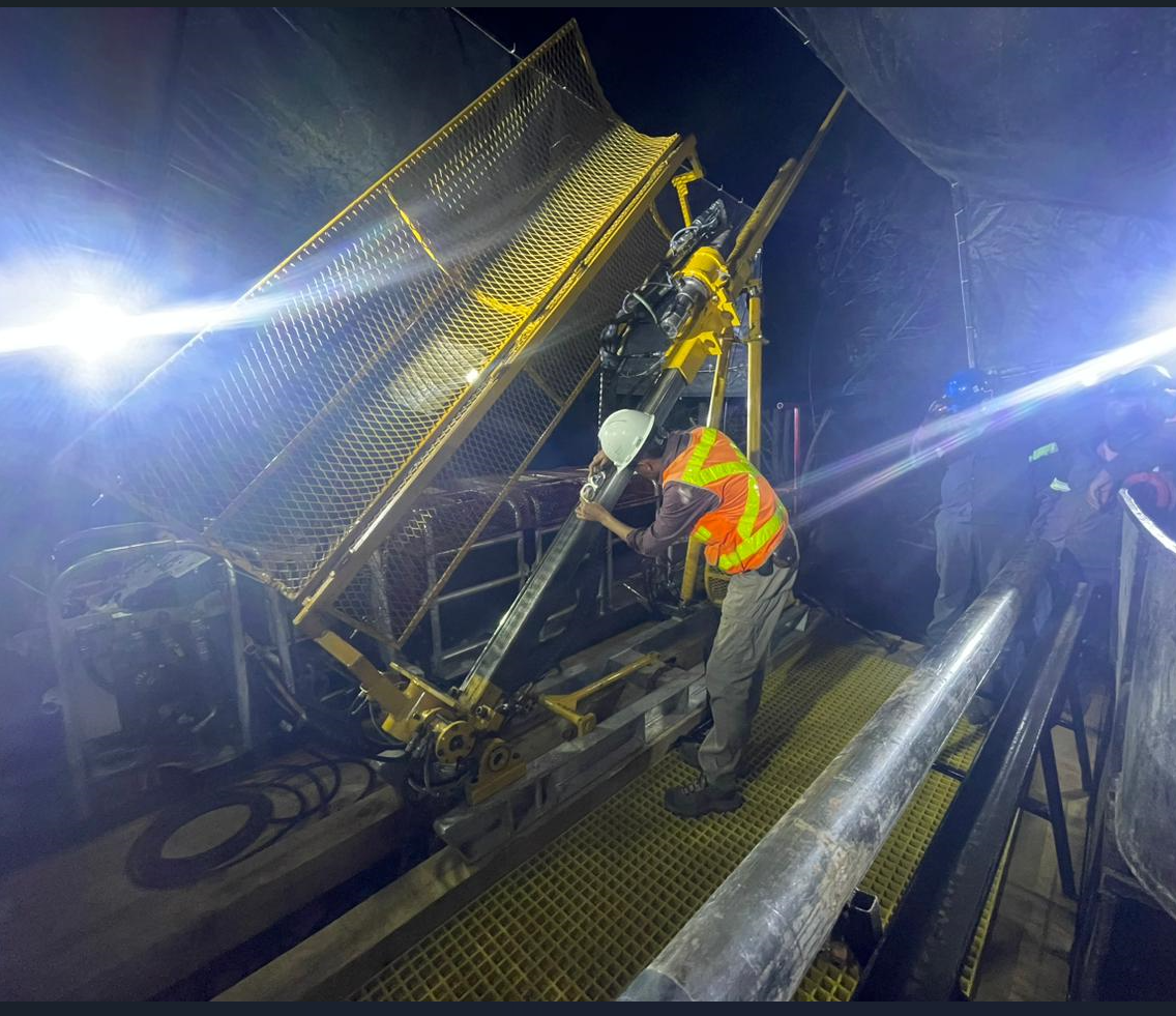
Drilling around the clock with core program 2024 at Cecilia project.
Qualified Person, QA/QC & Technical Disclosures
Riverside has compiled historical sampling and drill-hole data and has begun defining future drill targets. Fieldwork in 2018 has confirmed the existence of large regional northwest trending faults that service as conduits for mineralizing fluids. The larger northwest trending faults are intersected by smaller northeast and east-west structures which serve as areas of deposition for the rising gold bearing fluids. These complimentary structures have been mapped by Riverside and outlined by recent soil sampling surveys. Riverside’s 3D model of the litho-structural setting and the controls on the Cecilia mineral system shows a relationship of rhyolite dome-related polymetallic ore systems providing high-potential drill targets at various levels in the gold-silver mineral system, including targets that are not readily apparent in bedrock exposures found at surface.
The scientific and technical data contained in this outline pertaining to the Cecilia Project was reviewed and approved by Freeman Smith, P.Geo., a non-independent qualified person to Riverside Resources, who is responsible for ensuring that the geologic information provided in this news release is accurate and who acts as a “qualified person” under National Instrument 43-101 Standards of Disclosure for Mineral Projects.